Showing posts with label Indonesian Tourist Sites. Show all posts
Showing posts with label Indonesian Tourist Sites. Show all posts
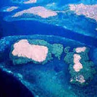
Komodo National Park
>
Komodo National Park is located in the center of the Indonesian archipelago, between the islands of Sumbawa and Flores. Established in 1980, initially the main purpose of the Park was to conserve the unique Komodo dragon (Varanus komodoensis) and its habitat. However, over the years, the goals for the Park have expanded to protecting its entire biodiversity, both terrestrial and marine. In 1986, the Park was declared a World Heritage Site and a Man and Biosphere Reserve by UNESCO, both indications of the Park's biological importance.
Komodo Island
Komodo National Park includes three major islands: Komodo, Rinca and Padar, as well as numerous smaller islands creating a total surface area (marine and land) of 1817km (proposed extensions would bring the total surface area up to 2,321km2). As well as being home to the Komodo dragon, the Park provides refuge for many other notable terrestrial species such as the orange-footed scrub fowl, an endemic rat, and the Timor deer. Moreover, the Park includes one of the richest marine environments including coral reefs, mangroves, seagrass beds, seamounts, and semi-enclosed bays. These habitats harbor more than 1,000 species of fish, some 260 species of reef-building coral, and 70 species of sponges. Dugong, sharks, manta rays, at least 14 species of whales, dolphins, and sea turtles also make Komodo National Park their home.

Komodo national park beach
Threats to terrestrial biodiversity include the increasing pressure on forest cover and water resources as the local human population has increased 800% over the past 60 years. In addition, the Timor deer population, the preferred prey source for the endangered Komodo dragon, is still being poached. Destructive fishing practices such as dynamite-, cyanide, and compressor fishing severely threaten the Park's marine resources by destroying both the habitat (coral reefs) and the resource itself (fish and invertebrate stocks). The present situation in the Park is characterized by reduced but continuing destructive fishing practices primarily by immigrant fishers, and high pressure on demersal stocks like lobsters, shellfish, groupers and napoleon wrasse. Pollution inputs, ranging from raw sewage to chemicals, are increasing and may pose a major threat in the future.

Komodo
Today, the Komodo National Park and Putri Naga Komodo, PT are working together to protect the Park's vast resources. Our goals are to protect the Park's biodiversity (both marine and terrestrial) and the breeding stocks of commercial fishes for replenishment of surrounding fishing grounds. The main challenge is to reduce both threats to the resources and conflicts between incompatible activities. Both parties have a long term commitment to protecting the marine biodiversity of Komodo National Park.
Samosir Island and Lake Toba
>
From Medan to Lake Toba access can be done through Tebing Tinggi continue to Siantar and crossing in Parapat (Ajibata). While other alternative is through the path ;Brastagi, Kabanjahe, Tongging, Sidikalang, then through the Tele, Pangururan crossing to Samosir Island. Its natural beauty is the main attraction of Lake Toba. As far as the eye could see the calm expanse of water surrounded by mountains andhills, sometimes punctuated by clouds and fog that hung, giving a sense of coolnessand peace of mind.

Lake Toba,
on the way to Harianboho and Tele, after Pangururan.
Entering the island of Samosir, cultural nuances of the thick ready to welcome our arrival, with cultural heritage and dynamic variety.

Batak Toba house on Samosir Island
Complementing its potential as an RTD (Regional Tourist Destination), dozens oflodgings are ready to accommodate tourists, both in the area Parapat and SamosirIsland.As a destination photography, this area meets the requirements to record the beauty of nature, human activities and cultural heritage of the nation hundreds of years old. With all that the Lake Toba and Samosir Island, not surprisingly, when its position in the Tourism Map of Indonesia, is in great position 5 along with the island of Bali,Mount Bromo, Tana Toraja and the island of Lombok.

Wooden dolls to show Sigale-Gale,
near the tomb of King Sidabutar - Tomok
Hopefully in the coming years the Government more look alive again to fix theinfra-structure in the Area Toba Samosir, so that its appeal was not hurt by the difficultroads and bridges impassable.
Bunaken Island
>
Bunaken is an area of 8.08 km² island in the Bay of Manado, located in the northern island of Sulawesi, Indonesia. This island is part of the city of Manado, the provincial capital of North Sulawesi, Indonesia. Bunaken Island can be achieved by speed boat (speed boat) or a rented boat with about 30 minutes journey from the port city of Manado. Around the island there Bunaken Bunaken marine park which is part of the Bunaken National Park. This marine park has a marine biodiversity one of the highest in the world. Scuba diving attracts many visitors to the island. Overall Bunaken marine park covers an area of 75,265 hectares with five islands within it, namely the island of Manado Tua, Bunaken Island, Island Siladen, Mantehage Island follows several children his island, and island Naen. Although covering an area of 75,265 hectares, the location of the dive (diving) is limited in each of the five beaches that surround the island.

Bunaken marine park has a 20 point dive (dive spot) with varying depth of up to 1344 meters. Of the 20 diving points, 12 points among them diving around Bunaken Island. Twelve point dive is the most frequently visited by divers and lovers of the beauty of underwater scenery.

Most of the 12 point dive in Bunaken Island lined up from the southeast to the northwest of the island. In this region there are underwater great walls, which is also called the hanging walls, or a giant rock walls that stand vertically and curved upward. These rock walls are also a source of food for fish in the waters around Bunaken Island.
Borobudur Temple
>
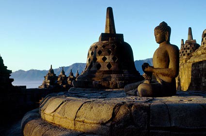
The monument is both a shrine to the Lord Buddha and a place for Buddhist pilgrimage. The journey for pilgrims begins at the base of the monument and follows a path circumambulating the monument while ascending to the top through the three levels of Buddhist cosmology, namely Kāmadhātu (the world of desire), Rupadhatu (the world of forms) and Arupadhatu (the world of formlessness). During the journey the monument guides the pilgrims through a system of stairways and corridors with 1,460 narrative relief panels on the wall and the balustrades.

Evidence suggests Borobudur was abandoned following the 14th-century decline of Buddhist and Hindu kingdoms in Java, and the Javanese conversion to Islam. Worldwide knowledge of its existence was sparked in 1814 by Sir Thomas Stamford Raffles, then the British ruler of Java, who was advised of its location by native Indonesians.
Ubud Bali
>
Ubud is a remarkable town in the middle of the island of Bali. For more than a century, it has been the island's preeminent centre for fine arts, dance and music. While it once was a haven for scruffy backpackers, cosmic seekers, artists and bohemians, Ubud is now a hot spot for literati, glitterati, art collectors and connoisseurs. Famous names walk its busy sidewalks everyday. Elegant five star hotels and sprawling mansions now stand on its outskirts, overlooking the most prized views in Bali.

Nonetheless, Ubud is still popular with backpackers, mystics and all the finest fringe elements of global society. Ubud is not "ruined". Its character is too strong to be destroyed. It still draws people who add something; people who are actively involved in art, nature, anthropology, music, dance, architecture, environmentalism, "alternative modalities," and more.
Ubud is arguably the best place to use as a base if you're visiting Bali; if you're looking for culture, comfort, nature and inspiration. Ubud is surrounded by most of the things that bring people to Bali -- scenic rice fields, small villages, art and craft communities, ancient temples, palaces, rivers, cheap accommodation and unique luxury hotels. And it's central location makes it easy to get from Ubud to the mountains, beaches, and major towns.

Why peruse these web pages?
The real Ubud is under the surface. There are plenty of interesting things on the main streets, but most of the magic of Ubud is hidden away. In the backstreets, backwaters, courtyards and cafes. In people's hearts, minds, and dreams. This part of the Bali web site was built to show you how to go behind the facade and find the real Ubud, and the real Bali, without having to spend all your time searching for it.

There's no point in repeating what's in the guidebooks, so we've tried not to. If you're interested in Ubud, there are at least a dozen guidebooks on Bali available and they all provide information on Ubud. Use this web site before you go to guidebooks, to find out what makes Ubud so special. Then use it after the guidebooks for up-to-date information, news and features about our extra ordinary town.
(Source : http://www.indo.com)
Lombok Island
>
Lombok is an island in West Nusa Tenggara (Nusa Tenggara Barat or NTB) province, Indonesia. It forms part of the chain of the Lesser Sunda Islands, with the Lombok Strait separating it from Bali to the west and the Alas Strait between it and Sumbawa to the east. It is roughly circular, with a "tail" (Sekotong Peninsula) to the southwest, about 70 km across and a total area of about 4,725 km² (1,825 sq mi).

The provincial capital and largest city on the island is Mataram. It is somewhat similar in size and density with neighboring Bali and shares some cultural heritage, and is now like its neighbor become a hot tourist destination, but is administratively part of NTB along with sparsely populated Sumbawa. It is surrounded by a number of smaller islands locally called Gili.

The island is home to some 3.16 million Indonesians as recorded in the decennial 2010 census, and in 4 regencies along with the provincial capital Mataram.

Tana Toraja (South Sulawesi)
>
Tana Toraja is one of the Indonesian tourist attraction, inhabited by a tribe who inhabit the mountains of Toraja and maintaining a distinctive lifestyle and still show the original Austronesian lifestyle and culture are similar to Nias. This area is one tourist attraction in South Sulawesi.
Pallawa
Tongkonan Pallawa is one tongkonan or traditional house that very interesting and were among the bamboo trees on the hilltop. Tongkonan is decorated with a number of buffalo horn that is attached at the front of traditional house. Located about 12 km to the north of Rantepao.

Londa
Londa is the steep rocks on the side of a typical tomb Tana Toraja. One was located on high ground from the hill with a cave in which the corpse crates are set according to the family line, the other one left open hillside views overlooking the green expanse. Located about 5 km to the south of Rantepao.

Ke'te Kesu
The object of this charming village of Tongkonan, rice barns and buildings in the surrounding megaliths. About 100 yards behind this village there is a cliff with the grave cemetery site dependent and tau-tau in a given building stone fence. Tau-tau shows the daily appearance of the owner. This village is also known as carving skills possessed by its inhabitants as well as a great place to shop for souvenirs. Located about 4 km from southeast Rantepao.

Stone Tumonga
In this area you can find about 56 stone menhirs in a loop with 4 trees in the middle. Most stone menhir has a height of about 2-3 meters. From here you can see the beauty of Rantepao and surrounding valleys. Located in the area Sesean with altitude 1300 meters above sea level.

Lemo
This place is often referred to as the home of the spirits. At the funeral Lemo yanng we can see the corpses stored in the open air, amid the steep rocks. This cemetery is the combination of death, art and ritual. At certain times clothing from the bodies will be replaced with a ceremony Ma 'Nene.

Jayawijaya Mountains
>
Jayawijaya Mountains is the name for the mountain range that extends lengthwise in the center of the province of West Papua (Indonesia) to East Papua (Papua New Guinea) in Papua Island. Rows of Mountains which have some of the highest peak in Indonesia was formed by the removal of the sea floor thousands of years ago. Even at the height of 4800 masl, fossilized sea shells, for example, can be found in limestone and clastic rocks that are in the Jayawijaya Mountains. Therefore, besides being a heaven for hikers, mountain paradise Jayawijaya also a world geological researchers. Jayawijaya Mountains are also the only mountain in Indonesia, which has a peak covered with eternal snow.

The history of the formation of Jayawijaya Mountains
According to geological theory, originally the world only have a continent named Pangea at 250 million years ago. Continent Pangaea split into two to form the continents Laurasia and the Eurasian continent. Eurasian continent burst back into Gonwana continent that later would become the mainland of South America, Africa, India, and Australia.
Precipitation is very intensive in the continent of Australia, plus the occurrence of plate collision between the Indo-Pacific plate with the Indo-Australian on the seabed. Plate collision resulted in the island arc, which also became the forerunner of the islands and mountains in Papua.

As a result of the appointment process is ongoing, sedimentation and tectonic events along under the sea, within a period of millions of years to produce high mountains as you can see today. Evidence that the high mountains of Papua Island and its never been part of the deep seafloor can be seen from the fossil remains in rocks Jayawijaya.
Jayawijaya peaks
Jaya peak 5030 masl
Yamin peak 4535 masl
Idenberg peak 4673 masl
Mandala peak 4650 masl
Trikora peak 4730 masl
Leuser Mountain National Park
>
Leuser Mountain National Park is a representative type of coastal forest ecosystems, and lowland tropical rain forests to mountains.

Orang Utan
Almost the entire area is covered by dipterocarp forest thick with several rivers and waterfalls. There are rare plants and typical of a giant umbrella leaf (Johannesteijsmannia altifrons), Raflesia flower (Rafflesia atjehensis and R. micropylora) and Rhizanthes zippelnii which is the largest flower with a diameter of 1.5 meters. In addition, there is a unique plant or plant strangler fig.
Rare and endangered species contained in the national parks, among others, introspective/ orangutan (Pongo abelii), gibbon (Hylobates syndactylus syndactylus), Sumatran elephant (Elephas maximus sumatranus), Sumatran rhino (Dicerorhinus sumatrensis sumatrensis), Sumatran tiger (Panthera tigris sumatrae), forest goat (Capricornis sumatraensis), hornbills (Buceros bicornis), sambar deer (Cervus unicolor), and jungle cat (Prionailurus bengalensis sumatrana).
Gunung Leuser National Park is one defined by UNESCO as a Biosphere Reserve. Based on the cooperation between Indonesia and Malaysia, also designated as a "Sister Park" with Taman Negara National Park in Malaysia.

Leuser Mountain National Park
Some locations / attractions to be visited:
Gurah. View and enjoy the natural scenery, canyons, hot springs, lakes, waterfalls, observation of wild animals and plants such as flowers Raflesia, orangutans, birds, snakes and butterflies.
Bohorok. Place the rehabilitation of orangutans and natural attractions form a panorama of the river, camping grounds and bird watching.
Kluet. Boating on rivers and lakes, trekking tours in the coastal forest and caves. This area is the habitat of Sumatran tigers.
Sekundur. Camping, cave tours and wildlife observation.
Ketambe and Suak Carambola. Research primates and other wildlife researcher who comes home and library.
Gunung Leuser (3404 m asl) and Mt. Pecan (3314 m asl). Climbing and mountain climbing.
River rafting in Alas. Activity rafting from Gurah-Muara Situlen-wave for three days.
Cultural attractions outside the Park is Lake Toba Festival in June on Lake Toba and Malay Culture Festival in July in Medan.
The best visiting season: June to October each year.
How to reach the location: Medan-Kutacane is ± 240 km or 8 hours by car, Kutacane-Gurah/Ketambe is ± 35 km or 30 minutes by car, Medan-Bohorok/Bukit Lawang is ± 60 km or 1 hour by car, Medan- Sei Betung / Sekundur is ± 150 km or 2 hours by car, Medan-Tapaktuan is ± 260 km or 10 hours by car.

Leuser Mountain National Park
Hanging Stone and Origin of Parapat City
>
In one remote village on the outskirts of Lake Toba in North Sumatra, there lived a husband and wife with a beautiful daughter named Chrysanthemum.In addition to beautiful, Chrysanthemum is also very diligent in helping parents work in the fields. Every day the small family working on their farm located on the shores of Lake Toba, and the results are used to meet daily needs.
One day, Chrysanthemum go to the fields alone, because there is a need both parents in a neighboring village. Chrysanthemum only accompanied by her beloved dog called the Toki. Arriving at the fields, she did not work, but he just sat thoughtfully looking at the natural beauty of Lake Toba. Looks like he is facing a difficult problem solved. While his dog, the Toki, come sit next to him staring at his face as if to know what's Chrysanthemum thinks her employer is. Once in a while the dog's barking to distract the boss, but her employer still preoccupied with her thoughts.

Indeed the last few days Chrysanthemum face always looked glum. He was very sad, because it will be married by her parents with a young man who was his cousin. Though he has established an affair with a young man his choice and has promised to build a happy home. He was very confused. On the one hand he does not want to disappoint his parents, and on the other hand if she could not have parted with youth idol of his heart. Therefore felt unable to bear the heavy burden, he was getting desperate.
"God! Servant was not able to live with this burden, "complained Chrysanthemum.
A few moments later, Chrysanthemum moved from his seat. With tears loose, he walked slowly toward the Lake Toba. Apparently she wanted to end his life by jumping into Lake Toba's rugged steep. While the Toki, followed his master from behind while barking.
With thoughts that continue raging, Chrysanthemum walked toward the cliffs of Lake Toba without watching the road in its path. Unexpectedly, he suddenly plunged into the hole large stone to go far into the bottom of the hole. The black rock that makes the atmosphere in the hole was getting dark. Beautiful girl was very frightened. At the bottom of a dark hole, he felt the walls of rock was moving closer would clamp.
"Help ... ...! Help ... ...! Help me, Toki!" Chrysanthemum voice asks for help to her beloved dog.
The Toki understand if the employer requires his help, but he can not do anything, except just barking at the mouth of the hole. Several times Chrysanthemum screaming for help, but the Toki is really not capable menolongnnya. Finally she was getting desperate.
"I'd rather be dead than suffer a long life," Chrysanthemum resigned.
The walls of rock that move increasingly closer.
"Parapat ...! Parapat the rock ...! Parapat, "cried Chrysanthemum stone told press her body.
While the Toki who knows his master in danger kept barking at the mouth of the hole. Feel unable to help his employer, he soon ran back to the house to ask for help.

Arriving at the house of his master, Toki's parents immediately went to the new Chrysanthemum who happened to come from neighboring villages to walk to her home. Toki barking while scratching the ground to notify the parents was that the Chrysanthemum in danger.
"Toki ..., where Chrysanthemum? What happened to him? "Asked the father to the dog Chrysanthemum. Toki kept barking ran back and forth to take them to a place.
"Sir, it looks like Chrysanthemum in danger," said the mother of Chrysanthemum.
"Mom was right. The Toki invites us to follow him, "said the father Chrysanthemum.
"But it was dark, sir. How do we get there? "Said the mother of Chrysanthemum.
"My mother prepared a torch! I will seek help from neighbors, "cried the father.
Soon, the whole neighborhood had gathered at the home page Chrysanthemum father carrying a torch. After that they followed the Toki to the scene. When I got them in the fields, the Toki directly toward the mouth of the hole. Then he barked as he held out his mouth stretched into a hole to notify the residents that the Chrysanthemum at the bottom of the hole.
Both parents Chrysanthemum immediately approached the mouth of the hole. What a surprise when they saw a hole big enough rock on the edge of their fields. Inside the hole there was a faint voice of a woman: "Parapat ...! Parapat the rock! Parapat! "
"Sir, listen to that voice! Itukan voices of our children! Chrysanthemum's mother cried in panic.
"Right! That sounds Chrysanthemum! "Replied the father participated in panic.
"But, why did he shouted: Parapat, Parapat the rock?" Asked the mother.
"I do not know, bu! Looks like there's something wrong in there, "said the anxious father.
Mr. Farmer was trying to light up the hole with a torch, but the bottom of the hole was so deep that can not be penetrated by torchlight.
"Chrysanthemum ...! Chrysanthemum ...! "Shouted the father of Chrysanthemum.
"Chrysanthemum ... my daughter! This mother and father came to help! "The mother come yelling.
Several times they cried, but did not get a response from the Chrysanthemum. Only voice drifted Chrysanthemum who ordered the stone was docked for menghimpitnya.
"Parapat ...! Parapat the rock! Parapat! "
"Chrysanthemum ... my daughter!" Chrysanthemum mother screamed again, crying hysterically.
Residents who were present at the site trying to help. One of the residents handed a rope to the bottom of the hole, but the slap was not touched at all. Chrysanthemum's father is increasingly concerned with their children. He also decided to follow her daughter's plunge into the rock hole.
"Mom, hold this torch!" Ordered the father.
"Daddy going?" Asked the mother.
"I want to follow Chrysanthemum into the hole," she answered firmly.
"No dad, very dangerous!" Prevent the mother.
"Yes sir, the hole was very deep and dark," said one resident.
Chrysanthemum's father finally the attack. A moment later, suddenly the sound of thunder. Earth rocked by fierce as if about to end. Rock hole suddenly close itself. The cliffs at the edge of Lake Toba was falling. Chrysanthemum's father and mother and all populations ran thither to save themselves. They left the mouth of the stone pit, so the Chrysanthemum The poor can not be saved from the crush of rock.
Some time after the earthquake stopped, suddenly appeared a large rock that resembles the body of a girl and as if hanging on the wall of the cliff at the edge of Lake Toba. Local people believe that the stone was the incarnation of the oppressed Chrysanthemum rock in the hole. By their stone was later given the name "Hanging Rock".

A few days later, came the news about the events that befall her. Residents flocked to the scene to see the "Hanging Rock" is. Residents who witnessed the incident told other residents that before the hole was closed, audible voice: "... Parapat Parapat Parapat the rock ...!"
Hence the word "Parapat" they say, and many are told, then the Week is located on the shores of Lake Toba was later given the name "Parapat". Parapat is now a small town one of the most attractive tourist destinations in North Sumatra Province, Indonesia.
*Parapat in Batak language means moor

Bangka Belitung Island
>
Belitung is an Island in South East Asia, a part of Nation archipelago. Belitung is ruled by Indonesia since 1950 and became a district of South Sumatra province. On November 21st, 2000, Belitung and Bangka Island has been approved to become the 31st province of Indonesia separated from South Sumatra. This new province is called ‘Kepulauan Bangka Belitung’ province. This Island is placed at 107o 35' - 108o 18' Latitude and 2o 30' - 3o 15' Longitude.

Matras Beach
The length of the diameter from East to West is about 79 km and North to South about 77 km. The total land is 480.060 hectares with 189 small islands surround Belitung. Some of them are quite big with a couple of villages. They are Mendanau Island, Seliu Island, Nadu Island and Batu Dinding Island. Most of Belitung population is come of Melayu ethnic and most of them are Moslem. There are some other ethnics likes Chinese, Javanese, Balinese and some people from Sumatra like Palembang, Minang and Batak. Belitung regency consists of 9 districts and 69 villages. The capital of Belitung is Tanjungpandan, which stay at North West of this Island. The other large towns are Manggar, Gantung, Kelapa Kampit and Sijuk. The main resources, which also become the main product of Belitung Island, are tin mining, kaolin, quartz sands, and granite rock. The plantation are mainly palm oil, pepper, coconut, coffee, natural rubber, and vegetable.

Parai Tenggiri Beach
If seen from its tourism sector, Belitung is an island with beautiful beaches, the unique landscape with its purely white sand, and the crystal clear seawater. Belitung is also popular with its granite boulder white stones beach in Tanjung Tinggi, Tanjung Kelayang, Tanjung Binga dan Lengkuas Island. This beautiful nature is also accompanied by hundreds of small islands, which add the beautiful tourism area in Belitung Island. Belitung Island is one of the best and unique beaches own in Indonesia.

Romodong Beach
Geographically
North coast of the island is South China Sea, Java Sea on the South coast, Kari Mata strait on the East close to Borneo Island and Gaspar strait on the West close to Bangka island. The land is about 4833 square km, 89 km long (East to West) and 69 km wide (North to South) with diversified terrain, hilly areas and extensive tracks of marshland. The climate is tropical, temperature around 27 - 31 C degree during the day and 23 - 25 C degree during the night. There only 2 season a year, rainy season (120mm) from October to April and hot season during April to October. The highest land is Tajam Mountain, only 500m above the sea. The others are just a hill likes Burung Mandi, Kubing, Kik Karak, Peramun, Selumar, Guda, ect.
The land surface is originally tropical forest, but since the development palm oil industry in 1992 more than 40% of the surface are palm oil plantation.
Nias Island
>
Nias (Nias language Tano Niha) is an island located in the west of the island of Sumatra, Indonesia. The island is inhabited by a majority tribe Nias (Ono Niha), which still has a megalithic culture. This area is important attractions such as surfing (surfing), traditional house, dive, jump rock. The island with an area of 5625 sq km has a population of 700,000. This region is the major religion of Protestant Christians. Nias is now divided into four districts and 1 city, namely Kabupaten Nias, South Nias regency, Nias West, North Nias District, and City Gunung Sitoli.

Hombo Stone in Bawomataluo
Tsunami & earthquake 2004 and 2005
On December 26, 2004, 2004 Indian Ocean earthquake occurred on the west coast of this island that led to the tsunami as high as 10 meters in area and Mandrehe Sirombu. The death toll from this incident amounted to 122 people and hundreds of families homeless. On March 28, 2005, the island was again rocked by earthquakes, was believed to be an aftershock following the incident in December 2004, but now the incident was the second strongest earthquake in the world since 1965. At least 638 people were reportedly killed, and hundreds of buildings were destroyed. Almost no public housing buildings throughout the island of Nias which suffered no damage from the quake.
According to the Rehabilitation and Reconstruction Agency (RRA) Nias Representative, the disaster has caused 13,000 houses destroyed, 24,000 houses were severely damaged, and about 34,000 houses were slightly damaged. A total of 12 ports and docks were destroyed, 403 damaged bridges and 800 km district roads and 266 km provincial roads were destroyed. A total of 723 schools and 1938 places of worship destroyed.

Beach Lagundri Sorake
Nias Island
Same as other areas in Indonesia, Nias island also has a tour for tourists visiting the area in the country and abroad. Since the tsunami and earthquake in 2004 and 2005, the island of Nias tried to get up to develop the tourism potential that there are back on the island of Nias. among others, nias island tourism potential that could attract tourists. There Gomo places of historic heritage items (megaliths), the Gulf coast in the presence of The Heritage (Howu-Howu Cafe), Beach Lagundri Sorake, Hombo Stone in Bawomataluo, Batu islands, the island of Telo and other mainstay attractions.
Brastagi Highlands in North Sumatra
>
Jakarta has a peak tourism as well as with Lembang Bandung, Medan has also the peak tourist attractions are no less interesting and beautiful. Namely Brastagi area, a trip from Medan to Berastagi take 1.5 to 2 hours using a private vehicle travel.With public transport can be taken within 3 hours, because the distance the city of Medan to Berastagi travel approximately 50km away. along the way we can enjoy beautiful views to the left and right beside the road we could see the scenery of tea plantation and tobacco, and daily activities of society northern Sumatra.
.jpg)
Brastagi View
Before entering the Brastagi we will pass Kaban ginger, here a lot of tea plantations and tobacco plantations, many traditional markets around Kaban this ginger.Activities of traders and buyers in the market eligible to be photographed, and the people were very friendly with the arrival of tourists and tourists who see. After that we went on a trip to Berastagi, here the air was getting cool and cold. He wanted to stop by dikedai coffee to enjoy coffee and the view around the mountains.
Berastagi is a very beautiful area, the area which is located in North Sumatra that have a height of 1400 meters above sea level. The air here is very clean and cool, this because it is surrounded by mountains and forests - forests that are very beautiful.Does not feel the trip as long as 1.5 hours a lot of fun. From the hills we can enjoy views of the green and could see the volcano and Sibayak Sinabung. Sibayak volcano is still active today and has a height of 2000 meters, the location of this Sibayak mountain not far from Berastagi.
Sibayak Mountain
Not only that, Brastagi very famous for vegetables and fruit - fruit, fruit that is very famous here is passion fruit. Passionfruit Brastagi very popular until the whole of Indonesia, and many made quintessence syrup. Indeed dibrastagi if we do not enjoy the fruits Brastagi did not complete it's like, let alone cold weather and cool very supportive of us to eat more food.

Fruit Market in Brastagi
After that we continued to Tongging attractions, there are a large waterfall that is Sipiso Piso waterfall. Piso name means knife, this waterfall is sharp and in surrounded by a deep ravine in the northern Sumatran tana, the distance to the location of this waterfall that is 24 km from Kabanjahe. and is located around the edge
Northern part of Lake Toba. Disekiling has views of waterfalls and gorges are very beautiful, high-piso waterfall Sipiso approximately 130 meters. I am very interested to get to this waterfall, as the distance from the top down this waterfall is pretty much when on foot. Finally I decided to walk down a path toward Sipiso piso Waterfall, to walk a steep curve and this should be very cautious. Many paths that have been damaged and not infrequently we have to crawl and clinging to the side of the road, it is advisable to use shoes and drinking water to taste. Fortunately in every way a lot of residential houses are made for the rest of the walkers feet, so if you are not strong or sudden rain during the trip we can get enough rest.

Sipiso - Piso Waterfall
Arriving based Sipiso Piso Waterfall, lost our sense of fatigue because of the river and waterfall scenery seen directly is very beautiful. Eve is radiated very cool because debris from the ears of water waterfall wet our face that makes us linger longer live under, after taking some photos we finally continued our journey upward. At the time of behind the new road was tired, because it does not feel way to the waterfall is down. And now we have to climb up and over.

Toba Lake View
Once above the struggle, we are in the Tour Tongging, tongging situated on the edge of Lake Toba in the north near Sipiso piso waterfall. It was from here is very beautiful view of Lake Toba, toba lake flanked by two mountains of rock along the bottom. We unwind here, after struggling to climb out from under Sipiso piso waterfall. Like tiredness disappeared instantly when we enjoy the beauty of Lake Toba

Tongging
Bali Island
>
With a population recorded as 3,891,000 in 2010, the island is home to most of Indonesia's small Hindu minority. In Bali's population adhered to Balinese Hinduism while most of the remainder follow Islam. It is also the largest tourist destination in the country and is renowned for its highly developed arts, including dance, sculpture, painting, leather, metalworking, and music. Bali, despite being a tourist haven for decades, has seen a surge in tourist numbers in recent years.

Temple In Bali
Bali was inhabited by about 2000 BC by Austronesian peoples who migrated originally from Taiwan through Maritime Southeast Asia. Culturally and linguistically, the Balinese are thus closely related to the peoples of the Indonesian archipelago, the Philippines, and Oceania. Stone tools dating from this time have been found near the village of Cekik in the island's west.
Balinese culture was strongly influenced by Indian and Chinese, and particularly Hindu culture, beginning around the 1st century AD. The name Bali dwipa ("Bali island") has been discovered from various inscriptions, including the Blanjong pillar inscription written by Sri Kesari Warmadewa in 914 AD and mentioning "Walidwipa". It was during this time that the complex irrigation system subak was developed to grow rice. Some religious and cultural traditions still in existence today can be traced back to this period. The Hindu Majapahit Empire (1293–1520 AD) on eastern Java founded a Balinese colony in 1343. When the empire declined, there was an exodus of intellectuals, artists, priests, and musicians from Java to Bali in the 15th century.

Sanur Beach
The first European contact with Bali is thought to have been made in 1585 when a Portuguese ship foundered off the Bukit Peninsula and left a few Portuguese in the service of Dewa Agung. In 1597 the Dutch explorer Cornelis de Houtman arrived at Bali and, with the establishment of the Dutch East India Company in 1602, the stage was set for colonial control two and a half centuries later when Dutch control expanded across the Indonesian archipelago throughout the second half of the nineteenth century (see Dutch East Indies). Dutch political and economic control over Bali began in the 1840s on the island's north coast, when the Dutch pitted various distrustful Balinese realms against each other. In the late 1890s, struggles between Balinese kingdoms in the island's south were exploited by the Dutch to increase their control.
The Dutch mounted large naval and ground assaults at the Sanur region in 1906 and were met by the thousands of members of the royal family and their followers who fought against the superior Dutch force in a suicidal puputan defensive assault rather than face the humiliation of surrender. Despite Dutch demands for surrender, an estimated 1,000 Balinese marched to their death against the invaders. In the Dutch intervention in Bali (1908), a similar massacre occurred in the face of a Dutch assault in Klungkung. Afterwards the Dutch governors were able to exercise administrative control over the island, but local control over religion and culture generally remained intact. Dutch rule over Bali came later and was never as well established as in other parts of Indonesia such as Java and Maluku.

Jimbaran Beach
In the 1930s, anthropologists Margaret Mead and Gregory Bateson, and artists Miguel Covarrubias and Walter Spies, and musicologist Colin McPhee created a western image of Bali as "an enchanted land of aesthetes at peace with themselves and nature", and western tourism first developed on the island.
Imperial Japan occupied Bali during World War II, during which time a Balinese military officer, Gusti Ngurah Rai, formed a Balinese 'freedom army'. The lack of institutional changes from the time of Dutch rule however, and the harshness of war requisitions made Japanese rule little better than the Dutch one. Following Japan's Pacific surrender in August 1945, the Dutch promptly returned to Indonesia, including Bali, immediately to reinstate their pre-war colonial administration. This was resisted by the Balinese rebels now using Japanese weapons. On 20 November 1946, the Battle of Marga was fought in Tabanan in central Bali. Colonel I Gusti Ngurah Rai, by then 29 years old, finally rallied his forces in east Bali at Marga Rana, where they made a suicide attack on the heavily armed Dutch. The Balinese battalion was entirely wiped out, breaking the last thread of Balinese military resistance. In 1946 the Dutch constituted Bali as one of the 13 administrative districts of the newly proclaimed State of East Indonesia, a rival state to the Republic of Indonesia which was proclaimed and headed by Sukarno and Hatta. Bali was included in the "Republic of the United States of Indonesia" when the Netherlands recognised Indonesian independence on 29 December 1949.

Tari Pendet
The 1963 eruption of Mount Agung killed thousands, created economic havoc and forced many displaced Balinese to be transmigrated to other parts of Indonesia. Mirroring the widening of social divisions across Indonesia in the 1950s and early 1960s, Bali saw conflict between supporters of the traditional caste system, and those rejecting these traditional values. Politically, this was represented by opposing supporters of the Indonesian Communist Party (PKI) and the Indonesian Nationalist Party (PNI), with tensions and ill-feeling further increased by the PKI's land reform programs. An attempted coup in Jakarta was put down by forces led by General Suharto. The army became the dominant power as it instigated a violent anti-communist purge, in which the army blamed the PKI for the coup. Most estimates suggest that at least 500,000 people were killed across Indonesia, with an estimated 80,000 killed in Bali, equivalent to 5% of the island's population. With no Islamic forces involved as in Java and Sumatra, upper-caste PNI landlords led the extermination of PKI members.
Subscribe to:
Posts (Atom)


